
Gautam Pradhan, WREC Dryland Research agronomist.
Agriculturists and researchers continue to develop technologies and strategies that decrease negative effects on crop performance and yield. Some examples of technology that is helping improve farming is precision agriculture, topography, and UAV.
Precision Agriculture is a management strategy that collects and analyzes temporal and spatial data to support management decisions. It is known to improve resource use efficiency, productivity, quality, profitability, and sustainability of agricultural production.
Topography is a landscape surface resulting from elevation data. According to North Dakota State University, the elevation data may come from actual surveys of the landscape with a laser transit, or from LIDAR (light detection and ranging) data or RTK (real-time kinetics)-GPS (global positioning satellite) signals. Topography is known to be one of the major factors affecting nutrition content and yield in the soil. In some regions, topographical land features can explain even mid-double-digit percentage of yield variability.
The impact of topography is important in precision agriculture management. Accurate elevation data and topographic attributes play a large part in precision agriculture, including site-specific applications of seed, fertilizer, and water, management zone delineation, designing contours or terraces and precision leveling plans, and planning soil and water conservation programs for enhanced profitability.
There are several precision agriculture software applications that can be used to carry out these management practices. Satellite images of growing crops can be accessed easily for almost all regional fields. For zone delineation, it is important to find an image from a year that is characteristic of a particular growing season. The normalized differential vegetative index band from the satellite in a growing crop when the rows are closed directly before flowering is a good time to use.
Hand-held active optical sensors are also available and can be attached to a sprayer or cultivator tool, allowing image data to be obtained during a normal field operation. These sensors result in maps that are finer resolution compared with a 30-m satellite image – although the images won't be as fine as an aerial photo. These types of sensors provide the same data with full sun as they would in the dark, even clouds passing would not change the data acquired.
In addition to this, sensors are being developed to allow their site-specific placement in specific field locations at the soil surface or within a crop canopy. According to North Dakota State University, "signals from these sensors can be transmitted via within-field repeater stations to a grower computer for real-time spatial sensing of micro-climatic measurements, such as canopy humidity and temperature levels, that might be important to initiate site-specific fungicide application."
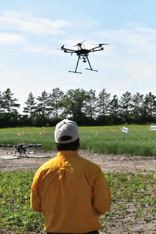
At the Williston Research Extension Center (WREC), researchers are using precision agriculture practices to help aid crops in times of drought.
In North Dakota, drought is the single most crucial abiotic factor affecting yield and quality of dryland crops. With the help of precision ag practices, growers can help mitigate drought affected crops.
"Plant physiological traits such as the normalized difference vegetation index (NDVI), normalized difference red edge (NDRE), and canopy temperature (CT) are directly related to crop growth and yield; a stress tolerant crop usually has higher NDVI/NDRE and low CT as compared to a susceptible crop," said Gautam Pradhan, WREC Dryland Research agronomist.
These traits, along with plant height and green area index can help in the identification of high yielding drought tolerant genotypes from standing crops. Although, these traits are time sensitive; for example, the CT of a plant in the morning will be entirely different than in the afternoon. However, the collection of these data manually from thousands of plots requires a tremendous amount of time and labor, and breeders are not using these traits in genotype selection.
"Therefore, there is a need of an application of precision agriculture, i.e., an application of high throughput phenotyping system comprised of geographic information systems, remote sensing, and geographic positioning system, which enables the measurement of physiological/canopy data from thousands of plots quickly (within minutes), frequently (6-7 times during the growing season), and accurately georeferenced," said Pradhan.
Pradhan has been working with drones and sensors to collect data on plant traits. The data collected, will be correlated with growth and yield components, and help breeders to develop high yielding drought tolerant genotypes of spring wheat, and barley. "The long-term goal of this project is to create selection tools for cereal breeders that help in the rapid development of drought-tolerant varieties."


Reader Comments(0)